The North Coast Gateway: Mapping Your Adventure
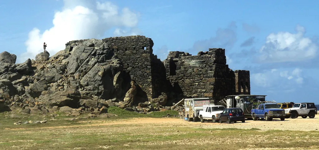
The Bushiribana Gold Mill Ruins serve as the primary anchor for Aruba’s rugged “wild side.” Situated on the windward northeast coast, the ruins mark the transition point where the island’s paved infrastructure gives way to limestone cliffs, volcanic desert, and crashing Atlantic surf. By positioning Bushiribana as a central hub, visitors can efficiently batch several high-rated attractions into a single “North Coast Circuit,” minimizing travel time between the remote, unpaved sections of the island and the more manicured resort districts of Palm Beach and Eagle Beach. Understanding the coastal geology of this region is essential, as the terrain dictates the pace of travel and the type of equipment required for a safe excursion.
This stretch of coastline is defined by its exposure to the relentless trade winds and the high-energy waves of the Atlantic. Unlike the leeward side of the island, where the water is calm and the sand is fine, the north coast is a graveyard of coral rubble and volcanic basalt. The proximity of the ruins to other geological and historical sites makes it the logical starting point for an itinerary that moves from the architectural mastery of the 19th-century smelter toward the natural wonders of the Arikok National Park. Efficiency is key here; the island does not forgive the unprepared traveler who underestimates the distances or the difficulty of the paths.
Maximize your journey: By grouping the ruins with the Natural Bridge and Alto Vista, you save nearly 45 minutes of driving time compared to visiting them as separate excursions from the hotel district.
| Attraction | Distance from Ruins | Key Feature | Recommended Vehicle |
|---|---|---|---|
| Natural Bridge & Baby Bridge | 1.2 Miles | Limestone Arches | 4×4 or SUV |
| New Natural Pool (Cave Pool) | 0.3 Miles | Cliff Jumping & Swimming | 4×4 Recommended |
| Alto Vista Chapel | 3.2 Miles | Historical Solitude | Standard Car / SUV |
| Arikok National Park (Vader Piet) | 5.1 Miles | Desert Landscapes | 4×4 Required |
| Donkey Sanctuary | 4.8 Miles | Historical Logistics | Standard Car |
Natural Bridge and the Legacy of the 2005 Collapse
The original Natural Bridge was once a titan of the Caribbean, a massive limestone arch carved by centuries of wave action that spanned nearly 100 feet. On September 2, 2005, the structure succumbed to the combined forces of gravity and internal erosion, collapsing into the surf below. Today, the site remains a major destination, though it serves more as a testament to the temporary nature of coastal features. Visitors can still view the massive boulders of the original bridge resting in the water, providing a sobering look at the power of the Atlantic. Immediately adjacent to the ruins of the titan bridge sits the “Baby Bridge,” a fully intact limestone arch that offers a safe and picturesque alternative for those looking to document the island’s unique formations.
The site is also home to the “Thirst Aid Station,” a visitor center that functions as the only formal refreshment and restroom hub on this specific stretch of the north coast. It is a critical stop for those following the transport guide, as hydration is paramount in the shade-free desert environment. For travelers seeking a more secluded experience, a short trek away from the main parking lot leads to “The Three Bridges.” This rare triple-arch formation is frequently overlooked by tourists who stay near the visitor center, offering a quiet vantage point to observe the volcanic shoreline without the crowds typically found at the larger ruins.
The New Natural Pool (Cave Pool)
Located less than 500 meters from the Bushiribana ruins, the “New” Natural Pool is a geological sinkhole in the limestone terrace. It is distinct from the more famous “Conchi” pool located further south within the national park. Accessing this pool requires a descent down a rugged, hand-crafted wooden ladder that leads directly into a limestone basin. For the more adventurous, the pool offers a 10-to-15-foot cliff jump into brackish, deep blue water. The depth is sufficient for jumping, but the water’s clarity varies based on the tide and recent wave activity, making a visual check of the bottom essential before any leap.
What makes this specific site valuable is the internal cave feature. The pool extends back under a shaded limestone overhang, creating a rare cool microclimate where visitors can escape the north coast’s intense midday sun. This shaded area is often populated by small fish and provides a tranquil contrast to the violent crashing of the waves just a few meters away on the seaward side of the rock ledge. Because of its proximity to the gold mill, it is the ideal spot to cool off after exploring the interior of the smelter, as described in our things to do guide.
Arikok National Park: Northern Boundaries
Continuing southeast from the ruins leads directly to the northern boundary of Arikok National Park. This transition is marked by a shift from the limestone terraces of the coast to higher volcanic cliffs. One of the most significant sites in this northern sector is the Guadirikiri Cave. The cave is famous for its two large chambers that are naturally illuminated by “holes” in the ceiling. Between 11:00 AM and 1:00 PM, the solar angle is perfect, creating dramatic pillars of light—often called “Angel Light”—that pierce the darkness and illuminate the resident bat colonies. Photography here requires patience and a tripod, as the contrast between the light beams and the dark limestone walls is extreme.
Nearby, the Fontein Cave offers a different historical perspective. While Guadirikiri is known for its light, Fontein contains actual reddish-brown pictographs left by the Arawak Indians over 1,000 years ago. These drawings provide a rare cultural link to the island’s pre-colonial past. The northern park area is also home to the Dunes of Prins, where white sand dunes contrast sharply against the surrounding black volcanic rock. This geological transition is a rare sight and provides a unique backdrop for those interested in the island’s diverse ecosystems. Exploring these sections requires a 4×4 vehicle, as the tracks are composed of loose sand and jagged rock.
Andicuri Beach and Wariruri Bay
Andicuri Beach is widely regarded as the island’s premier spot for experienced bodyboarders due to its powerful “shore break.” The waves here break with significant force very close to the sand, creating a challenging environment that is generally discouraged for casual swimming. The bay is flanked by dramatic limestone cliffs that locals refer to as the “Shark’s Mouth” because of their jagged, tooth-like appearance. It is a location defined by raw energy, where the sound of the Atlantic is constant and the spray from the waves coats everything in a fine layer of salt.
Just north of Andicuri is Wariruri Bay, which features its own picturesque natural bridge. This arch is wide and flat enough that, in previous decades, local ATV tours used to drive directly across it. To ensure the preservation of the limestone structure, vehicular traffic is now restricted, and the bridge is only accessible to those on foot. The bay itself is a popular stop for horseback riding tours, offering a wide, sandy expanse that is shielded from the most extreme winds by the surrounding cliffs. It is a quintessential example of the rugged beauty found along the north coast routes.
Donkey Sanctuary Aruba: A Link to Mining History
While often viewed as a simple animal park, the Donkey Sanctuary has deep ties to the Aruban Gold Rush Chronicles. The sanctuary currently houses over 130 donkeys, many of which are descendants of the animals brought by Spanish settlers to serve as the primary mode of transport for gold ore. In the 19th century, these animals were the backbone of the mining industry, carrying heavy loads of quartz ore from the pits to the Bushiribana smelter and eventually transporting processed materials to Oranjestad. When motorized vehicles replaced them, many were released into the wild, leading to the feral population that the sanctuary now protects.
Visiting the sanctuary offers an interactive experience where guests can purchase feeding buckets of carrots and apples. It is a non-profit foundation where 100% of the proceeds are directed toward medical care and sheltering for the island’s wild donkey population. The sanctuary provides a necessary emotional and educational break from the harsh, sun-drenched environment of the ruins. It is a highly recommended stop for families, as the gentle nature of the animals offers a contrast to the rugged, industrial history of the gold mill. For more on preparing for this environment, consult our packing essentials guide.
San Nicolas: The Sunrise City
Located at the southern tip of the island, San Nicolas is a mandatory stop for those finishing a full-day island circuit. Once a fading refinery town, it has been revitalized by the “Aruba Art Fair,” which invites international muralists to refresh the city’s walls annually. This means the “gallery” of the city is constantly evolving. The main artery of this transformation is Bernhard van de Veen Zeppenfeldtstraat, where the most famous 3D murals—including a massive lizard and a striking mother-and-child portrait—are concentrated. The street art provides a vibrant, contemporary contrast to the monochromatic limestone ruins of the north coast.
Beyond the art, San Nicolas offers a look into the island’s industrial soul. The massive refinery towers still dominate the skyline, acting as a modern bookend to the ancient smelting technology seen at Bushiribana. The town has a distinct rhythm compared to Oranjestad, with a more local, Caribbean feel that is less centered on the cruise ship industry. It is the best place to find authentic local eateries after a day of exploration. For advice on where to eat in the more remote areas closer to the ruins, see our refreshments and local food guide.
Strategic Travel Tips
The roads connecting these north coast sites are largely unpaved and consist of packed dirt, limestone, and loose volcanic rock. While a standard car can reach the Bushiribana Gold Mill Ruins from the inland side via paved roads from Santa Cruz, traveling between the ruins and Arikok or the Natural Bridge is significantly safer and more comfortable in a 4WD vehicle. The sharp volcanic rocks on the path to the Natural Bridge are notorious for causing tire punctures, and the ground clearance of an SUV is often required to navigate the deeper ruts formed by seasonal rains.
Check your spare tire and jack before leaving the resort area. The north coast is remote, and cellular service can be intermittent among the limestone outcrops near the ruins.
Local Guide Tip
Book a North Coast Circuit Tour

Aruba UTV, ATV Adventure to Secret Beach and Cave Pool
⭐ Aruba Experience
🔥 Booked 7 times today

Aruba UTV Tour with Natural Cave Pool and Cliff Jumping
⭐ Aruba Experience
🔥 Bestseller in 2026

National Park Arikok Jeep Safari Adventures
⭐ National Experience
🔥 Professional local guide included

Horseback Ride Tour to Natural Pool in Arikok National Park
⭐ Horseback Experience
🔥 Top Choice in Aruba

Aruba Jeep Tour: Natural Pool, Caves and Baby Beach Adventure
⭐ Aruba Experience
🔥 Instant confirmation after booking

Aruba Sunset Sail Cruise Aboard The Dolphin Catamaran
⭐ Aruba Experience
🔥 Booked 1 times today